Sign up, and we'll send you the latest issue directly to your inbox!
Support the Beat!
If the Beat has ever informed you, moved you, or made you feel a deeper connection to our city, we ask you to help us continue this journey. Your generosity keeps our presses running, our journalists digging deep, and our stories reaching every corner of Baltimore.
New West Baltimore trail proposal doesn’t meet city requirements for safer streets
Instead of a trail on Gwynns Falls Parkway, the city’s transportation department proposed utilizing bike lanes and bus-bike lanes on nearby alternate streets.
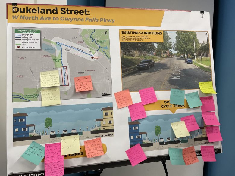
Attendees were encouraged to leave their feedback about the proposal on Post-it notes.
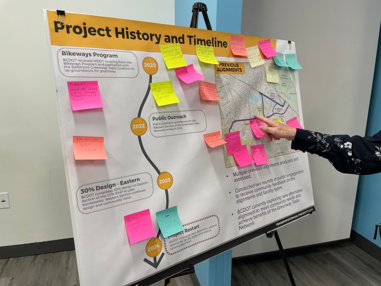
After more than a year of silence about plans for a West Baltimore trail connecting two of the city’s biggest parks, city transportation officials presented a new proposal on August 22 that would circumvent Gwynns Falls Parkway altogether and instead utilize bike lanes and bus-bike lanes on Liberty Heights Avenue, North Dukeland Street and West North Avenue.
But the proposal doesn’t meet the city’s own Complete Streets requirements for shared-use pathways — particularly the portions requiring trails to have some kind of separation from the roadway that would protect pedestrians, bicyclists and people using mobility devices from vehicular traffic.
Several parts of the proposal are also only designed for bicyclists and would not accommodate foot traffic.
“Do we really think it’s safe for somebody’s grandmother or a young parent pushing a stroller to be walking in the bus lane on North Avenue because we’ve called that a multi-use trail? That’s not a good idea,” said Kate Foster, mid-Atlantic director of trail development for Rails-to-Trails Conservancy.
“Do we really think it’s safe for somebody’s grandmother or a young parent pushing a stroller to be walking in the bus lane on North Avenue because we’ve called that a multi-use trail? That’s not a good idea.”
Kate Foster, mid-Atlantic director of trail development for Rails-to-Trails Conservancy
When asked about the lack of adherence to the Complete Streets requirements for shared-use paths, Department of Transportation officials appeared to be moving away from describing the planned pathway between Druid Hill Park and Leakin Park as a trail, despite years of outreach, advocacy, and planning for it as one.
“The vision of the Greenway Network Plan includes a 35-mile loop, connecting Baltimore’s existing stream valley trails and the waterfront promenade,” Stuart Sirota, deputy director for planning and sustainable transportation, wrote in a statement to Baltimore Beat.
“There may be portions of the 35-mile loop that do not meet the literal definition of ‘trail’ or ‘multi-use path’ as described in the Complete Streets Manual, but still provide a high-quality connection between the city’s existing greenway assets.”
A key part of the Complete Streets Manual is emphasizing equity in redesigning Baltimore’s streets to ensure that Black neighborhoods that have been disinvested in and often have lower rates of car ownership are prioritized for safer, more walkable streets.
”Baltimore’s history in transportation decisions negatively impacted Black and African American Communities. Not only were communities cut apart with high-speed roadways to prioritize the movement of cars, but these communities did not receive the same access to the services received by other wealthier neighborhoods throughout the city,” Baltimore Mayor Brandon Scott wrote in the introduction to the manual in 2021.
It’s unclear which portions of the trail network will end up as trails, providing multiple modes of access for residents and adhering to those equity requirements, and which portions will not.
The August 22 meeting was advertised as a Greenway Trail Network meeting connecting the two parks, and the Department of Transportation still describes the connection as a trail network on its website.
Sirota added that DOT would upgrade pedestrian infrastructure, particularly to comply with the Americans with Disabilities Act, in the segments where the pedestrian access would be separate from the bicycle access.
Foster, whose organization led advocacy for the Greenway Trail Network before handing the project over to DOT, pushed back on DOT’s new description of the trail network.
“The planned trail segment between Leakin Park and Druid Hill Park is not simply a “connection.” It represents a critical segment of a city-sponsored trail network that will provide access to the trail network for thousands of residents of West Baltimore,” Foster wrote in a text.
“Multi-use trails, which is what the Baltimore Greenway Trails are intended to be, are by definition off-road and built to accommodate all ages and abilities of walkers, rollerbladers and bicyclists.”
At the August 22 meeting, residents and advocates also raised concerns about the safety of mixed bike-bus lanes and the indirectness of the route compared to the previously proposed Gwynns Falls Parkway route. Poster boards set up around the room to describe different parts of the route and encourage direct feedback were covered in Post-it notes asking the department to revisit the Gwynns Falls version.
“This isn’t safe for adults, much less kids! The greenway is supposed to be all ages & all abilities,” one attendee wrote on one poster board.
“How is the pressure of an entire bus behind someone biking better than the pressure of being in car traffic?… What about wheelchair mobility users?” another commented.
Arica Gonzalez, a Hanlon resident who works with young adults through her community-building organization The Urban Oasis, noted that there seemed to be very few of her neighbors in attendance on August 22, a sign that the city may not have done enough to get the proposal in front of West Baltimore residents.
Of the 43 in-person attendees, only eight said they were from neighborhoods that the trail would connect — Greater Mondawmin, Panway and Hanlon, per DOT. The department did not collect neighborhood data from an additional 49 online attendees.
Gonzalez also felt that it wasn’t clear whether the proposal was open to tweaks or whether they were expected to veto or approve it as is. She hopes to see transportation officials redouble their efforts to engage with West Baltimore residents, particularly young adults who are looking for easier ways to navigate their neighborhoods.
“I think there is a much bigger opportunity for collaboration and ingenuity in the design,” Gonzalez said. “We’re gonna miss out on a lot of great ideas if we’re not having that conversation with the people impacted by the space.”
“We’re gonna miss out on a lot of great ideas if we’re not having that conversation with the people impacted by the space.”
Arica Gonzalez, Executive Director of the urban Oasis
The new route would connect to Baltimore City Community College, the transit hub at Mondawmin Mall, and two schools along North Dukeland Street, which advocates pointed to as an upside.
Jed Weeks, interim executive director of Bikemore, is in favor of bike lanes on Liberty Heights Avenue and North Dukeland Street, which he said should have been built years ago.
But without the separated infrastructure to protect pedestrians and bikers from car traffic, the proposed route will not fulfill the goals of the Greenway Trail Network, Weeks said.
“The trail network is designed to connect families, essentially, to amenities across the city. And if you get to any part of that trail and it’s not safe for a family to ride on, it undermines the entire corridor,” Weeks said.
He echoed the criticisms of attendees at the meeting who said the indirect route between Druid Hill Park and Leakin Park would make it more difficult for people to use the trail, adding that there were elevation changes on the new route that didn’t exist on the Gwynns Falls Parkway route.
“To me, it seems silly to just forfeit a route that literally has been studied for, at this point, 100 years, as a route that should have a trail on it,” Weeks said. “The original design of that road was a road with a trail down the median, and it was designed that way because it was a good idea then, and it’s a good idea now.”
Sanya Kamidi is a multimedia journalist and news editor at Baltimore Beat. She previously worked on audience and community engagement and neighborhood stories at The Baltimore Sun. Kamidi is a 2023-2024...
More by Sanya Kamidi